This is the first in a series examining how Geographic Business Intelligence (GeoBI) can help your organization realize better and deeper insights. In this post we’ll discuss some of the concepts that define, and should be considered for, a successful GeoBI program.
Business Intelligence (BI) encompasses the processes and technology that allow you to transform your data into information and analysis. This analysis leads you to insights that you can take action on, enabling you to improve your organization’s decisions and performance. It’s an essential part of any business strategy, so that you can leverage the data you have into greater business value.
But the traditional approach to BI has some limitations, and it can be enhanced to give your organization more value.
Becoming an Insight Driven Organization
Deloitte, in their 2016 Analytics Trends report, identified the Insight Driven Organization as one that uses cross-department, cross-domain analytics to make better decisions and to improve performance metrics. The key to shifting your BI platform from departmental, targeted analytics to enterprise-wide insights is to expand the way you look at your BI platform.
Specifically: look at how data from across your entire organization can be put together to form new analytics – analytics with more context and that provide exponential value to your business. Including spatial data, information and technologies in your current BI approach and strategy is what we refer to as Geographic Business Intelligence, or GeoBI.
What is GeoBI?
Traditional BI implementations include a data warehouse, extract-transform-load (ETL) processes, analyst tools, maybe organizational standards or governance rules around BI data. You might be in an exploratory phase with your BI program, or it might be pervasive in your organization.
At the same time, nearly every organization has some spatial data. Often this is managed by a GIS department, but it might also include spatial data such as locations in an asset management system, addresses in a CRM, sales and marketing districts, or linear networks like delivery schedules or public transit routes.
GeoBI is the idea that your spatial data can be an integral part of your business intelligence platform, and that this integration will provide you with deeper insights and better decision making.
So what does Geo BI consist of?
We’ve identified four key capabilities of a GeoBI program that need consideration when striving to be an Insight Driven Organization:
1. Platform Integration 
This is something we see in traditional BI implementations, but in GeoBI this refers more specifically to the integration of spatial or location information with other (non-spatial) business data. This might be “true” spatial data – such as coordinates or geometries – as well as what we call “pseudo-spatial” data such as city names or postal codes. Bringing this data together gives your business units access to this information so that they can use it as part of their BI analysis.
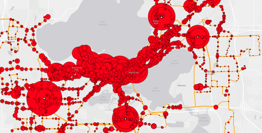
2. Spatial Analysis 
In BI we typically perform analysis that is some combination of data aggregation, slicing and dicing, and filtering. When we add location to the mix, we enable new ways to aggregate, slice and filter data. For example, we can group data by proximity to key locations, or ascribe measurements to regions or routes.
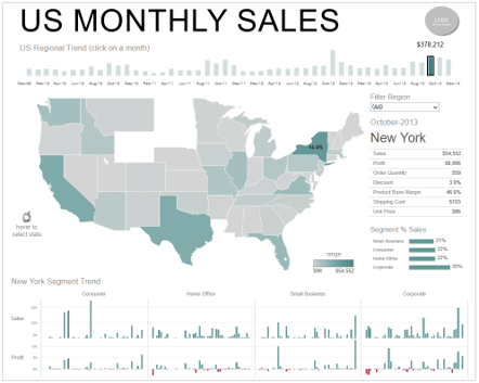
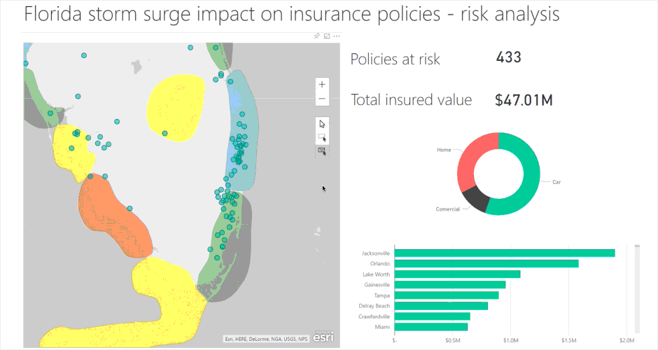
3. Visualization 
Visualization is a key part of any geographic analysis. Maps provide context for information, and the way in which we display or symbolize data can communicate a great deal of information.
4. User Interaction 
User interaction is a capability we typically find in a dashboard solution. The ability for an analyst to select and filter data interactively is part of what is referred to as “self service BI”, and enables analysts to identify and report on insights. Map-based interaction allows analysts to find new relationships and insights quickly and easily.
Building your GeoBI program with these four capabilities in mind will help ensure a successful implementation. Our next post in this series will outline some implementation approaches to consider – and ones to avoid.